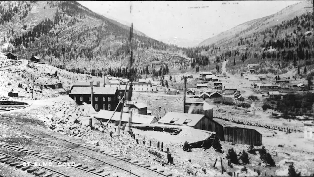
The Denver South Park & Pacific Railroad (D.S.P. & P. or South Park) reached Forest City (St.
Elmo) at the confluence of Chalk Creek and East Chalk Creek on 31 December
1880. The rails were in a construction race to reach the rich gold fields of the
Gunnison River Valley; Gunnison, Crested Butte, Lake City and the San Juan region beyond. As the "Pacific" in the herald implied, the South Park had ambitious goals set for itself. Immediately in front of their efforts was the Saguache
("sah-watch") Range - the Continental Divide.
The elevation at
the apex inside the tunnel was 11,524 feet and only about 500 feet
below the pass. The tunnel was 1772 feet long but measured as 1780 feet
daylight to daylight in March, 1900. At the east portal (Atlantic) the
track entered on a 24 degree curve that turned more than 90
degrees to the left Geographically, the tunnel is aligned north to south.
 |
| View directly before the train in the photo above. Poole Photo 2005 |
If you need more details about the Alpine Tunnel a good place to start would be Dow Helmers' "The Alpine Tunnel". Also, "The D.S.P.& P" by Mac Poor and Colorado R.R. Museum "Rail Annal No. 12" (Cornelius Hauch). There are many more publications in both books and magazines that are excellent resources for this and much more about the railroad. .
The South Park gauged the rails at what Coloradoans (note the CORRECT spelling of that noun!!) call Colorado Standard Gauge - 36" between the rails. (The rails were 30lbs to the yard.) This diminutive sizing was intended to reduce the costs of building a railroad in the Colorado Rockies where the motto was; "around the rocks, not through them". But this Tunnel - which was the only tunnel on the entire narrow gauge system for nearly 70 year of history - was an unavoidable exception, given the company goals.
Of course, this wasn't the only road into Tunnel Gulch. For many years prospectors had traipsed all over the district. Some of the trails they created or "developed" from the natives became wagon roads and eventually a toll road was built from Forrest City (St. Elmo) up Chalk Creek. It crossed the Continental over Williams pass. On its decent into Quartz Creek, this Alpine & South Park Toll Road was crossed by the railroad grade just above the feature known as "The Palisades" (a vertical rock formation that rises several hundred feet above the grading). Supplies via the Toll Road could be forwarded up grade from the crossing into Alpine, the small hanging valley that is the location of the Tunnel's Pacific portal.
On the Atlantic side there was a road from the Toll Road westward up Tunnel Gulch but the construction camp was still hundreds of feet above the creek and the road.
Supplies were also packed over Altman Pass from Atlantic construction site.When the bore finally broke through, the arrival of the grading at Atlantic improved the supply to both construction camps from the east portal. .
 |
| View from above the railroad grade at Romley, looking north and down grade. The Pomeroy Bridge is located just beyond where the road disappears. Poole Photo - 1987 |


No comments:
Post a Comment